
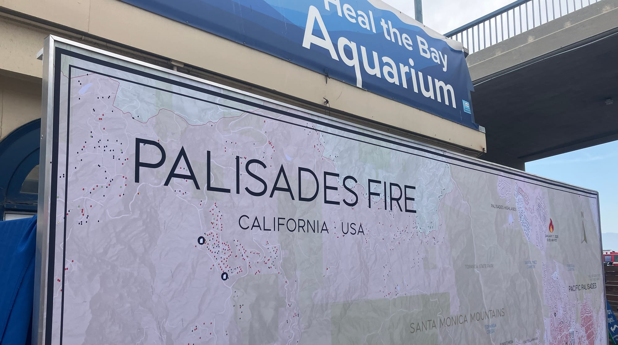
A billboard-sized fire damage map now on display at the Santa Monica Pier Aquarium is helping residents, visitors and policymakers grasp the full extent of the devastation caused by the Pacific Palisades wildfire.
Created by Highland Park-based production designer Noel McCarthy, the installation presents a detailed aerial overview of the destruction across the west side of Los Angeles, from the Palisades to the edges of Malibu, in a form meant to be both accessible and unflinching.
Unlike traditional recovery tools or online damage databases, McCarthy’s map is designed for physical presence. Printed using large-format trade show technology and mounted like fabric on a frame, the display offers viewers a chance to engage with the fire's impact spatially, slowly and face to face.
"You can look at drone shots of burned out lots all day long," McCarthy said. "But one burned out neighborhood looks like the next. You don't get the story until you see it laid out like this."
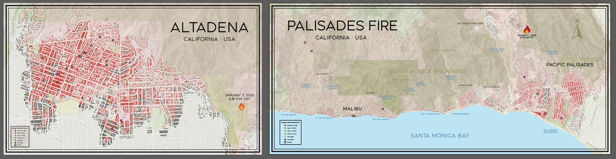
The Palisades map is not McCarthy’s first. After the Eaton Fire tore through Altadena, where he lives, McCarthy created a similar large-scale display that became a gathering place in the community. That project was self-funded and placed on private property. The current installation, in contrast, was backed by a grant from Los Angeles County Supervisor Lindsey Horvath’s office and developed in partnership with Heal the Bay. It is scheduled to remain at the Aquarium for an indefinite period, with possible appearances at upcoming beach cleanups and community events.
“This was never meant to be art,” McCarthy said. “To me, this is a tool. It’s about awareness, healing and understanding how we rebuild. I want people who were affected to feel seen and I want people who weren’t to understand the scale and empathize.”
The design was pieced together from data compiled by Los Angeles County’s Recovers map, which tracks post-disaster damage assessments. Working with colleagues from the commercial production world, McCarthy took about five days to composite hundreds of screenshots into a massive digital file, then consulted with locals to get neighborhood names and landmarks right. “I'm not a Westsider,” he said. “So I relied on the folks at Heal the Bay and others in the community to make sure everything made sense for the people who live here.”
Unlike the Altadena version, which zoomed in on a single neighborhood, the Palisades installation is deliberately broad. At the request of Horvath’s office and Heal the Bay, McCarthy ensured that the entire fire zone was represented, making it clear that the blaze was regional in scope. “This was all of Santa Monica Bay,” he said. “Not just one town.”
The map has already drawn attention for the way it invites reflection and conversation. McCarthy said he has watched people slowly trace the path of the fire, gesturing to the direction of the wind and the route of their evacuation. “It happens again and again,” he said. “First they reenact the day of the fire. Then they start pointing to places they know. Their home. Their school. Their walking route. Then it gets quiet. That’s when it hits.”
For many, the aftermath of the fire has brought more than emotional trauma. McCarthy, who has heard hundreds of personal stories since creating his first map, pointed to widespread insurance issues and bureaucratic hurdles that have left some residents with few good options. “People are finding out they’re underinsured,” he said. “There was a mobile park down by the highway, built like stacked container homes. Insurance is only covering the footprint of those units, not the second or third floors. People are going to get shafted.”
He also noted that the Altadena fire was especially damaging to renters, many of whom have not returned. In the Palisades and surrounding areas, he suspects a similar pattern will follow, with high costs and permitting delays pushing out longtime residents. “Every week there’s another article about insurance companies pulling back,” he said. “People are selling up and moving on.”
Though the Aquarium installation has brought new visibility, McCarthy is still searching for a more permanent home. He hopes to place the map somewhere in downtown Santa Monica, ideally on the Third Street Promenade or Palisades Park, where people can both view the physical scale of the damage and look out at the landscape it depicts. “To me, it’s important that this be somewhere public and accessible,” he said. “Not tucked away.”
The production designer says he’s also thinking about future iterations. With support from the original creators of the Recovers map, he has access to aerial photography from shortly after the fire and plans to track progress through subsequent cleanups. “This should be a historical document,” he said. “Something people can come back to, to remember, to learn and to build better next time.”
While the fires themselves may have passed, McCarthy believes the real work is just beginning. “There’s this moment after a disaster when people say it’s too soon to talk about it,” he said. “But it’s not. We need to talk now, while we’re still clearing the rubble. That’s how we build something stronger.”
scott.snowden@smdp.com