

Access to pier getting easier
SM PIER Josie and John Young love visiting here, but the tourists from London just wish it was a little bit easier to find their way.
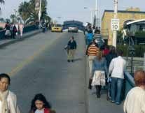
The couple routinely hike up and down the Santa Monica Pier when they visit the city’s most indelible landmark each winter, but that hike has become increasingly dangerous as the years pass.
“We often have to walk into the street if someone is coming in the opposite direction,” said Josie Young, as she stood at the top of the pier bridge at Ocean Avenue. “Just now, we had to move out of the way because a man was walking with a stroller. I think it would be a good idea to make (the sidewalks) a little wider... It would definitely be a lot safer.”
The Youngs aren’t alone. For decades, visitors, residents and those involved in the tourism industry have expressed frustrations with the narrow sidewalks and 13-inch high curbs along the pier bridge.
There is also the matter of the complicated course drivers must take to reach the parking lot adjacent to the pier, known as the 1550 Lot. Studies have shown that 60 percent of people entering the lot do so by making an illegal U-turn on Pacific Coast Highway.
The narrow road and high pedestrian traffic on the bridge can also make it difficult for emergency vehicles to get through.
“The lack of direct access to our pier and beaches remains an issue, not only for visitors, but for our residents,” said Misti Kerns, president and CEO of the Santa Monica Convention and Visitors Bureau (CVB). “During the recent beach summit, it came up on several occasions, both locally and outside of our community, as a negative.
“We must... offer people options before they arrive.”
The safety of the 650-foot bridge has also been called into question. Following the Northridge earthquake in 1994, the bridge suffered extensive damage, resulting in the permanent closure of stairs located on the south side. The current condition of the bridge could lead to collapse if there is another major seismic event, studies show.
Still, a solution to all those concerns may be in sight.
The Pier Restoration Corp. (PRC), a City Council-appointed body in charge of managing and promoting the pier, has endorsed one of six alternatives outlined in an environmental impact report being circulated throughout the city. PRC officials have been trying to gather support for the proposal before going to the City Council in late March.
City staff could not be reached for comment on which alternative will be recommended to the council.
Known as Alternative 2, the plan calls for a vehicle ramp to run parallel with the bridge before turning slightly north and connecting with the 1550 Lot. The north sidewalk would be removed and the south sidewalk, which runs adjacent to The Lobster restaurant and the Heal the Bay’s Santa Monica Pier Aquarium, would be widened considerably, to 16 feet.
The plan would require moving the famous pier sign 13 feet to the north, allowing for a wider, 28 foot roadway, according to PRC officials.
“We believe Alternative 2 is the best option because it is the only option that meets all of the objectives for the project, including better access, improved public safety, preservation of the historic integrity of the pier and improves traffic flow through downtown and better connects downtown businesses with the pier’s 4 million annual visitors,” said Ben Franz-Knight, executive director of PRC.
“By shifting pedestrian access to the south, we further our mission of educating the public about the pier’s historic nature by increasing their awareness of the Looff Hippodrome and Carousel, both a national and city landmark,” he said.
While the pier sign is a national landmark, the pier bridge is not. Franz-Knight said the sign has been moved in the past, most recently in the 1950s, when it was relocated from the middle of the bridge to the top, improving visibility from Ocean Avenue.
PRC has presented another option, whereby the sign would be moved just 5 feet to the north, allowing for a 24-foot roadway and an 8-foot walkway on the south that would widen to 16 feet further down the bridge.
OPEN FOR BUSINESS Prior to 1939, the pier — built in 1909 — and it’s available parking was accessed from a mostly level, packed dirt road starting at what is now Ocean and Colorado avenues. In the mid-1930s, the opening of PCH brought more tourists to Santa Monica via automobile, creating more of a traffic bottleneck at Appian Way. The addition of the McClure Tunnel necessitated the construction of a concrete bridge to the pier.
The new overpass opened on June 17, 1940. During that year, the Santa Monica Pier Businessman’s Association installed the famous pier sign to let the public know the new roadway was open.
THE COSTS OF PROGRESS Alternative 2 wouldn’t come cheap. Estimates place costs at around $7.5 million. It is the second-least expensive alternative on the table, discounting the alternative that recommends no upgrades at all.
The project would be paid for by a combination of state and federal funds, plus contributions from City Hall.
Other options include making the bridge accessible only to pedestrians, or extending the ramp down into and under the pier.

Originally published in the Santa Monica Daily Press print edition on February 21, 2007. Read the original PDF.